A cognitive map is a representative expression of an individual’s knowledge about the spatial and environmental relations of geographic space. Everyone has a unique relationship to his or her own environment, so each person’s cognitive map is different. I learned this the hard way back before the advent of GPS. Folks would give me directions to their homes in the days when I would make sales calls or later on when I’d make a pastoral visit. It didn’t help that some gave me landmarks like “go past the barn that used to be green,” or “turn left where the old trailer used to be.” I’d clear my throat and reply, “What color is that barn now and what took the place of the old trailer?” Often they couldn’t say, for their internal map was based on old programming and not the latest update. Some people still use their old flip phones, like Mark Harmon on NCIS, but that’s his quirk. They can get around, but it’s hard to get others to come on board with these old ideas.

Everyone’s map is different, for sure, but for some of us, the landmarks can change, but our memories aren’t replaced. Some people are like me, who get lost in a tea cup, so I’m unsure of where I am at any given time. This may be why I give some the impression I’m a tad “spacey.” Others can steer a sure and certain course at any time of the day or night to make their way home, like a carrier pigeon with an important message for those who await their arrival. Once I was riding with the men from the West Helena Church to the Methodist Camp for a meeting. I always liked the Methodist Men’s meetings, for they had steaks and other real food, not dainty salads like the women’s groups. Night was coming on and rural roads in the Arkansas Delta look much like one another in the gloom. Our driver could tell I was uncomfortable.
“What’s the matter, preacher?”
“I’ve only been to the camp in the daytime. This doesn’t feel right to me, somehow.”
“You know we all grew up hunting in these woods and rice fields. We know these places like the back of our hands.”
“I know. I also know I always get lost every time I go somewhere by myself.”
“Well, you don’t have to worry about getting lost tonight! We’ll get you there and back.”
“It’s probably better you’re driving, since we don’t want to miss supper.”
They laughed. They all had a much better cognitive map of their home county than I did, since they had spent their whole lives there and I’d only spent three years. Of course I grew up in my home town and even there I still managed to get confused about places, so I’m not sure my living anywhere longer would have filled out my cognitive map with more details.
Characteristics of Cognitive Maps:
- Diverse in nature and purpose. Cognitive mapping is used in a broad range of disciplines for a variety of purposes. Cognitive maps are the most general type of mental-model visualization.
- No restrictions on structure or form. Cognitive maps don’t have to adhere to a specific format. Thus, they’re often abstract and have no consistent hierarchy. They’re flexible and can accommodate a wide set of concepts or situations that need to be represented.
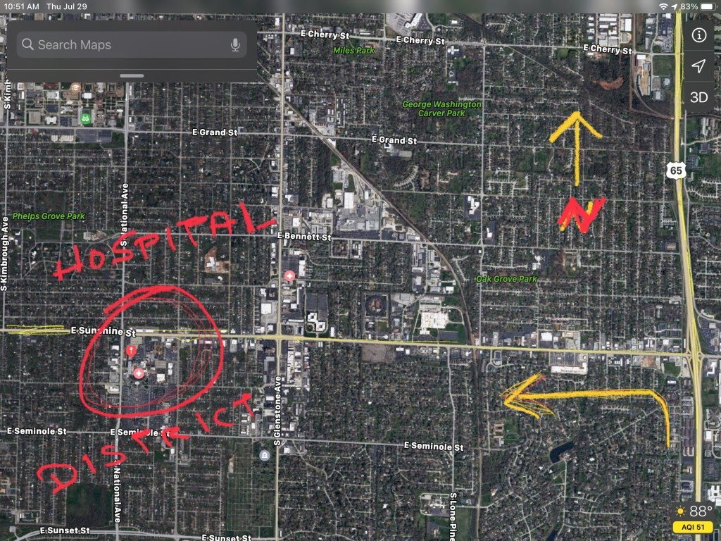
I usually get lost in a teacup, and my typical travel technique is to drive in the general direction of my goal and then circle it until I have it surrounded. I once drove to Springfield, Missouri to find the hospital there. Once I saw the blue H sign, I took the highway exit, and drove until I began to see a multitude of fast food shops along with drug stores and medical uniform shops. Once I saw physicians’ offices, I knew I was close. Then the height of the hospital building was unmistakable. I knew it would be located in this area, for my cognitive map of every city told me “this is how a hospital district is arranged.”

I’m not a direct point to point person, a fact which drives most of my friends crazy. They also insist on driving when we go places, so I guess they don’t like my usual scenic route. I’m well aware most people’s minds aren’t like mine, so I design my sermons so they can be understood by the greatest number, most of whom are logical or literal thinkers, who like one point to build upon another. This has always been a growth area for me, much like navigating directly to a destination. Yet I’ve always arrived (to everyone’s amazement) and somehow I’ve also found a sermon that didn’t put everyone to sleep. (Those who stayed out all night at the drag races sometimes gave me a challenge to preach in between their intermittent snores, but I digress.)

For instance, when I used to prepare my sermons, I often put notes on a legal pad throughout the week. Other ideas would percolate up to my consciousness and I would jot those down too. I would write some clarifying remarks out to the side and connect them to an idea already on the page. Sometimes I’d draw a circle around an idea, or enclose it in a box to make sure I’d emphasize it. Later in the week I’d number those ideas as to their prominence or order of presentation. This would go on throughout the week as I blindly drew the cognitive map of my sermon for Sunday from the depths of my heart and mind.
I couldn’t bring it in this form for my congregation, however, so I’d have to sit down to make sense of it. In other words, I needed to produce a map or outline of such clarity, a blind person could find their way to the main point of the sermon with ease. Once I got it in this form, it was a strong enough armament to hang a sermon upon. I could elaborate these points with Bible verses and illustrations from life. Then I’d sometimes chop a few limbs off, just to keep from driving in circles, but this is how I mapped out my sermons every week to get people from point A to point B without getting lost along the way. I never learned this direct method to travel in a car, however.

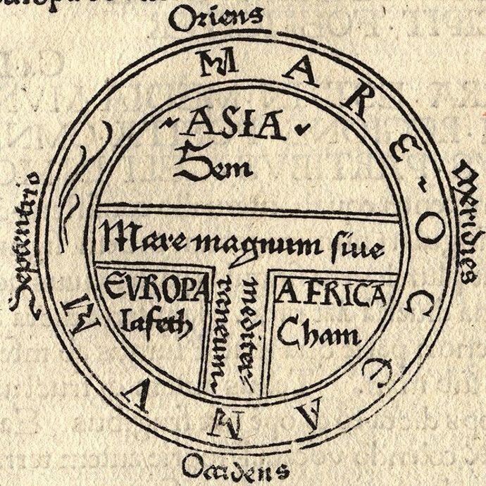
One of the earliest extant maps is the T and O map, first created by Isidore of Seville in 600 AD. It was an early attempt to envision the world on paper. The T in the circle represents the Mediterranean Sea, which partitioned the 3 continents Asia, Africa and Europe.
Most of us are more familiar with maps of city streets, state highways and byways, as well as world maps. If we visit the museums, or do a Google search, we can find interesting antique maps of how our ancestors viewed the world. The British Library has some of the oldest maps in its collection These images are surrounded by water, since people hadn’t sailed across the ocean yet. This world map comes from a beautifully illuminated copy of Beatus of Liébana’s ‘Commentary on the Apocalypse of St John’, a religious text from the 8th century held in high esteem by medieval Christians. This copy was made at the Spanish Monastery of San Domingo de Silos in 1106, a time when the monastery’s scriptorium was producing some of its finest work.

In this old map, Adam and Eve are shown with the serpent against a dark green background representing the verdant Garden of Eden. It’s a picture of a world centered round the Mediterranean Sea virtually unchanged since the 8th century and reflects an even older world-view inherited from Roman times. Beyond the Red Sea is a hint of an undiscovered fourth continent that some ancient thinkers, such as Pliny, the 1st-century Roman author, had suggested must exist in order to balance the known land masses of Europe, Asia and Africa.

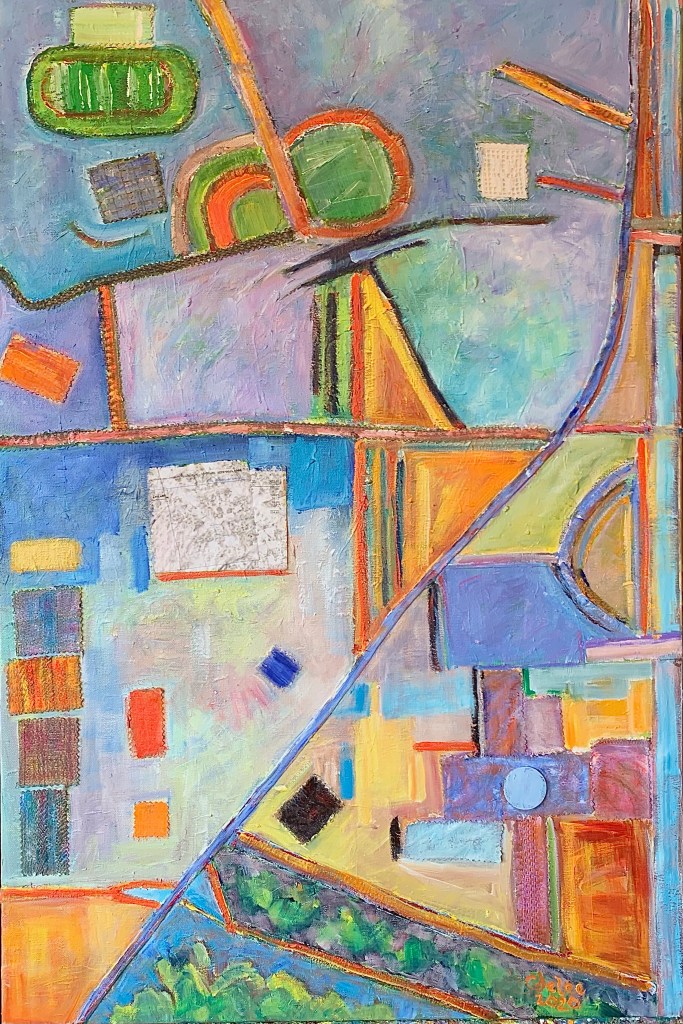
In my mixed media cognitive maps, I’ve kept the primary city streets, but selected only the geographic and architectural details which had meaning for me. I’ve used left over fabrics from the Covid masks I’ve made, old needlepoint seat covers from my parent’s garage, and antique crochet my grandmother made that she never sewed onto a pillowcase. I’ve often said, I’m going to “get around to it” and do something with these souvenirs from my ancestors, but this pandemic might not last that long. Also, I have other more pressing and exciting projects to pursue.

The pandemic has tossed my well conceived notions of how I live my life right out the window. Confined to my home, I longed to travel and to wander the city streets as I did in the days before Covid. While I had the grounds of my condominium property to explore, it wasn’t enough. When I began to look at the Google maps of the sites I’d painted before, I noticed I liked the patterns of the satellite views. Sketching out colors and shapes on the images saved from my iPad, I started making some preliminary works. Then I found some old paintings that no longer pleased me and began to rework them with maps of places which have meaning for me.

Now we’re a year and a half into the Covid emergency, but for some of us, our cognitive maps haven’t yet changed. Goldman Sacs estimates the United States would save $1 trillion in healthcare costs with a nationwide mask mandate, whereas hospitalizations nationwide cost $24 billion. We could save many lives, especially those of our vulnerable, youngest children. We also will need to vaccinate the whole world, for this plague knows no boundaries. Until all are safe, no one is safe.

I don’t have the type of mind that can conceive of a worldview in which I abdicate my responsibilities toward my neighbor. I’m too steeped in the biblical worldview, in which God calls Cain to account for killing his brother Abel, but Cain answers, “Am I my brother’s keeper?” God’s answer is “Absolutely!” The Hebrew ancestors once trusted in their Temple to protect them, rather than God. When the Babylonians took them into exile, they had to get a new vision, or a new cognitive map, of who they were as God’s people, for they had once tied God to the land of Israel only.
Ezekiel had a vision in which God spoke to him in a desert valley of dried bones:
“Prophesy to these bones, and say to them: O dry bones, hear the word of the LORD. Thus says the Lord GOD to these bones: I will cause breath to enter you, and you shall live. I will lay sinews on you, and will cause flesh to come upon you, and cover you with skin, and put breath in you, and you shall live; and you shall know that I am the LORD.” (37:4-6)

When our world changes, we either have to live in exile and despair or we can live in the power and presence of God. If we have a hope to return to our ancestral home, in our case, “the precovid era,” we have to survive this uncertain time. When this crisis passes, we’ll discover on our return the Temple needs rebuilding, the infrastructure of the city needs repairs, and the houses need care to become homes again. We’ll need communities to care for one another, especially for the weakest and the least of our brothers and sisters who live on the margins of society. Perhaps we shouldn’t go back to how “things used to be,” but use this crisis as an opportunity to create new visions for new maps, the maps which represent a better world for all humanity.

Joy and peace,
Cornelia
The New BauHaus
https://youtu.be/Efz67zwDU6k
The Hidden Costs of Covid Hospitalizations
https://www.forbes.com/sites/leahrosenbaum/2020/10/30/the-hidden-costs-of-coronavirus-hospitalizations/
Steven M. Weisberg, Nora S. Newcombe: Cognitive Maps: Some People Make Them, Some People Struggle, 2018
https://journals.sagepub.com/doi/10.1177/0963721417744521
